地震信号动态反演与数值模拟相结合改进滑坡过程重建

论文题目
Combining seismic signal dynamic inversion and numerical modeling improves landslide process reconstruction
Yan Yana,c, Yifei Cuib*, Xinghui Huangd, Wengang Zhange, Shuyao Yina, Jiaojiao Zhoua, Sheng Huf
a Key Laboratory of High-Speed Railway Engineering, MOE/School of Civil Engineering, Southwest Jiaotong University, Chengdu 610031, China
b State Key Laboratory of Hydroscience and Engineering, Tsinghua University, Beijing 100084,China
c Institute of Geographic Sciences and Natural Resources Research, Chinese Academy of Sciences, Beijing,100101, China
d China Earthquake Networks Center, Beijing 100045, China
e School of Civil Engineering, Chongqing University, Chongqing 400045, China
f College of Urban and Environmental Sciences, Northwest University, Xi’an 710127, China
*Corresponding author: Yifei Cui, e-mail: yifeicui@mail.tsinghua.edu.cn
研究内容
Abstract:Landslides present a significant hazard for humans, but continuous landslide monitoring is not yet possible due to their unpredictability. In recent years, numerical simulation and seismic inversion methods have been used to provide valuable data for understanding the entire process of landslide movement. However, each method has shortcomings. Dynamic inversion based on long-period seismic signals gives the force–time history of a landslide using an empirical Green's function but lacks detailed flowing characteristics for the hazards. Numerical simulation can simulate the entire movement process, but results are strongly influenced by the choice of modeling parameters. Therefore, developing a method for combining those two techniques has become a focus for research in recent years. In this study, we develop such a protocol based on analysis of the 2018 Baige landslide in China. Seismic signal inversion results are used to constrain and optimize the numerical simulation. We apply the procedure to the Baige event and, combined with a field geological survey, show it provides a comprehensive and accurate method for dynamic process reconstruction. We found that the Baige landslide was triggered by detachment of the weathered layer, with severe top fault segmentation. The landslide process comprised four stages: initiation, main slip, blocking, and deposition. Multi-method mutual verification effectively reduces the inherent drawbacks of each method, and multi-method joint analysis improves the rationality and reliability of the results. The approach outlined in this study could help us to better understand the landslide dynamic process.
Keywords: Landslide processes reconstruction, Seismic signal analysis, Dynamic inversion, Numerical simulation, 2018 “10.10” Baige Landslide.
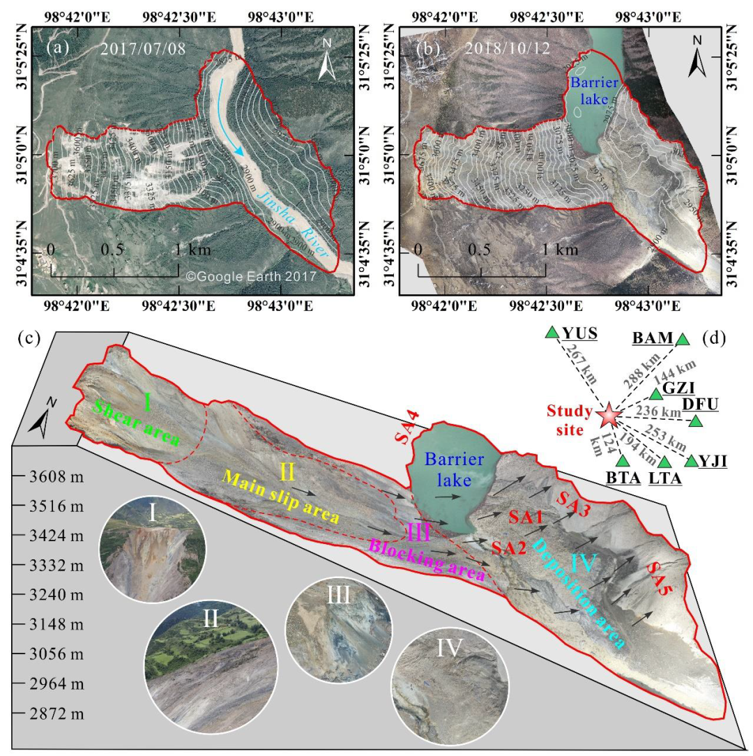
FIGURE 1 Location of the study area.(a) DEM of Baige landslide 2017:(b) DEM of Baige landslide after the 2018 event;(c) Schematic cross-section with remote sensing overlay showing key features of the Baige landslide;(d) Location of the Baige landslide (red star) relative to seismic stations (green triangles) used in the study. The remote sensing image map data of Fig 1. a. is from the Google Earth 2017, and the data of Fig 1. b. and Fig 1. c. are from the authors'own UAV photography measurements.

FIGURE 8 Dynamic inversion used to obtain Baige landslide characteristics.(a) Inverted force time history;(b) Estimated acceleration distribution over time;(c) Reconstructed velocity distribution over time from the inverted landslide force time history;(d) Reconstructed displacement distribution over time from the inverted landslide force time history. Corresponding absolute values are shown as dashed black lines.
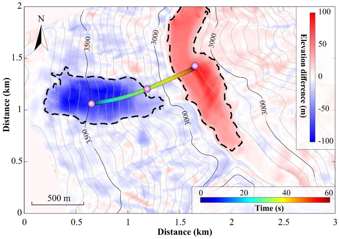
FIGURE 10Reconstructed horizontal trajectory of the Baige landslide from the seismic dynamic inversion. The base map is the elevation difference derived from DEMs and the reconstructed trajectory is shown by the colored dots and connecting timeline.

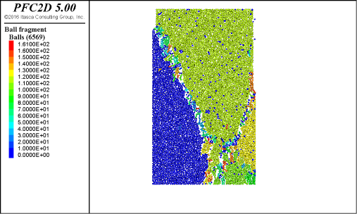
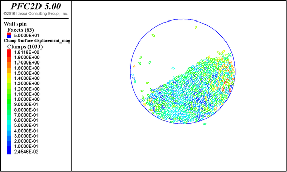
FIGURE 11 Simulated landslide velocity distribution calculated in MatDEM.(a) t=0 s;(b) t=10 s;(c) t=20 s;(d) t=30 s:(e) t=40 s;(f) t=50 s;(g) t=60 s:(h) t=80 s. The digital terrain model (DTM) data of Fig 11. are from the authors'own UAV photography measurements.

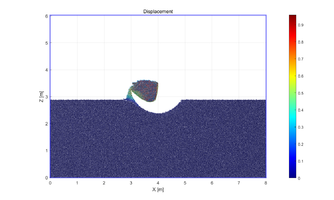
FIGURE 12 Comparison of landslide characteristics simulated using discrete element model with inversion results.(a) Average velocity:(b) Average displacement.
了解详情